Digimap workshop materials

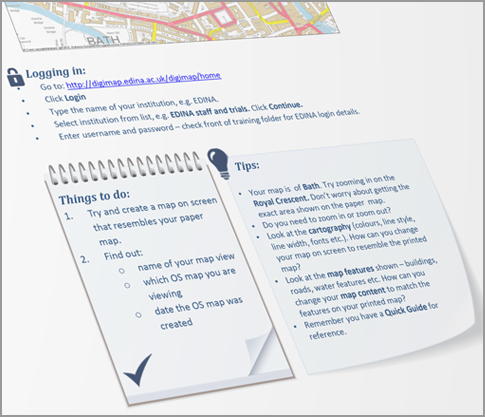
The resources below may be useful when you wish to run Digimap workshops at your institution.

All resources can be downloaded and adapted to suit your purposes.
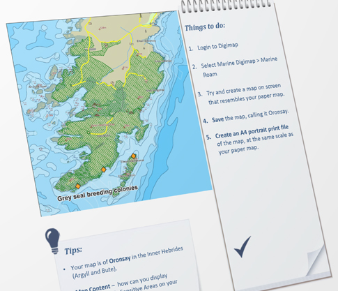
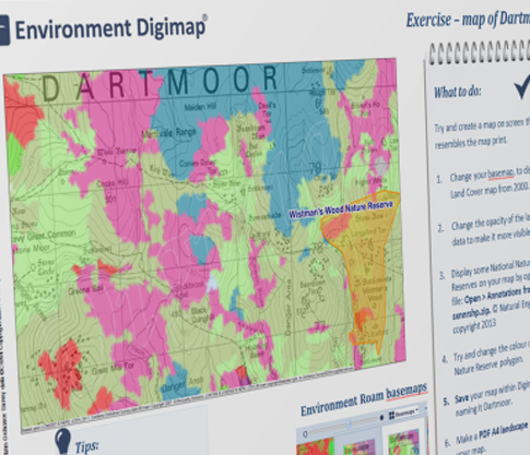
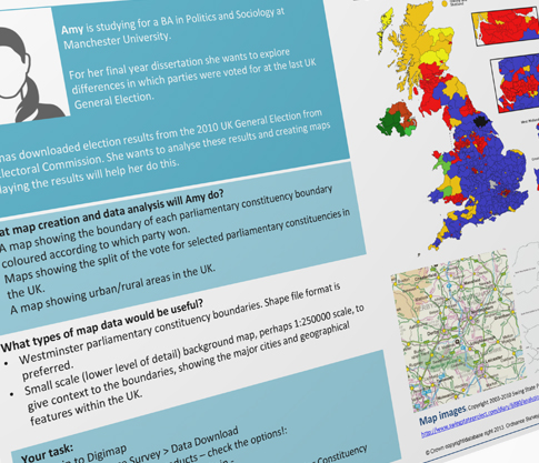
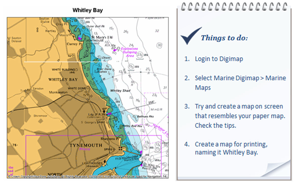
 

View contemporary Ordnance Survey maps. Print A3/A4. Custom feature selection and annotation available.

Roam Exercise 1: Search and select map features

On completing these exercises, users will be able to:

  • Search using a placename, postcode or grid reference

  • Zoom in and out of different map views

  • Move around the map by using the compass or clicking and dragging

  • Customise their maps by selecting from a range of base maps

  • Customise their maps by displaying features of their choice

  • Add a map overlay, Hillshading

  • Identify the OS map being viewed and its date of creation

Exercises Training Exercises outline a scenario, then provide step-by-step guidance to achieve it.

Zip file with 5 Roam exercises in PPTX format, plus trainer guide and Quick Guide.


View contemporary Ordnance Survey maps. Print A3/A4. Custom feature selection and annotation available.

Roam Exercise 2: Annotate, print and save maps

On completing these exercises, users will be able to:
  • Annotate maps in Roam with markers, labels, polygons

  • Save their maps, complete with annotations within Roam

  • Import annotations from a supplied file

  • Export annotations to their computers in Shape file format

  • Create a PDF print file and select a print scale

Exercises Training Exercises outline a scenario, then provide step-by-step guidance to achieve it.

Zip file with 6 Roam exercises in PPTX format, plus trainer guide and Quick Guide.


View historic maps of Great Britain, from 1840s to1990s. Town and county level mapping. Print A3/A4. Add annotations.

Ancient Roam exercise

 On completing this exercise, users will be able to:
  • Use a timeline to view historic maps from different decades

  • Select one map to view, from list of overlapping maps

  • Compare 2 maps of same area from different decades

  • Identify the publication date of the historic map on display


Exercises Training Exercises outline a scenario, then provide step-by-step guidance to achieve it.

Zip file with exercise, trainer guide and Quick Guide.


View British Geological Survey geological maps of Great Britain, with Ordnance Survey geographic background maps. Print A3/A4. Custom feature selection and map annotation available.

Geology Roam exercise

On completing this exercise, users will be able to:
  • View geological photos on a British Geological Survey map

  • Fade out background Ordnance Survey maps on geological maps within Geology Roam

  • Identify a rock on a geological map using the feature identification tool


Exercises Training Exercises outline a scenario, then provide step-by-step guidance to achieve it.

Zip file with exercise, trainer guide and Quick Guide.


View Hydrospatial vector marine mapping data of Great Britain. Last updated 2011. Print A3/A4. Custom feature selection. Add annotations.

Marine Roam exercise

On completing this exercise, users will be able to:
  • Select marine mapping features to display on a map

  • Annotate their map with points of interest

  • Import and display marine consultation areas on the map

  • Save their map and annotations within Marine Roam

  • Create a PDF print file of their map, at a custom scale


Exercises Training Exercises outline a scenario, then provide step-by-step guidance to achieve it.


Zip file with exercise, file of marine consultation areas for import, trainer guide and Quick Guide.


Marine Maps exercise

On completing this exercise, users will be able to:
  • View and print marine charts in the Marine Maps service

Exercises Training Exercises outline a scenario, then provide step-by-step guidance to achieve it.


Zip file with exercise and Quick Guide.


Environment Roam exercise

On completing this exercise, users will be able to:
  • Select marine mapping features to display on a map

  • Annotate their map with points of interest

  • Import and display a national nature reserve on their map

  • Save their map and annotations within Marine Roam

  • Create a PDF print file of their map, at a custom scale


Exercises Training Exercises outline a scenario, then provide step-by-step guidance to achieve it.


Zip file with exercise, nature reserve file for import, trainer guide and Quick Guide.


Download Ordnance Survey mapping data - wide range of scales, formats and map types available: backdrop maps, vector mapping data, land and height data, digital boundaries, postcodes, gazetteers.

Data Download exercise

On completing these exercises, users will be able to:
  • Order multiple map data products for a project area from download services in Digimap Collections

  • Identify where to change format, date or layers within the Data Download Basket

  • Identify where to reorder map data and change parts of the order

Exercises Training Exercises outline a scenario, then provide step-by-step guidance to achieve it.

Zip file with exercises in PPTX format, plus trainer guide and Quick Guides.


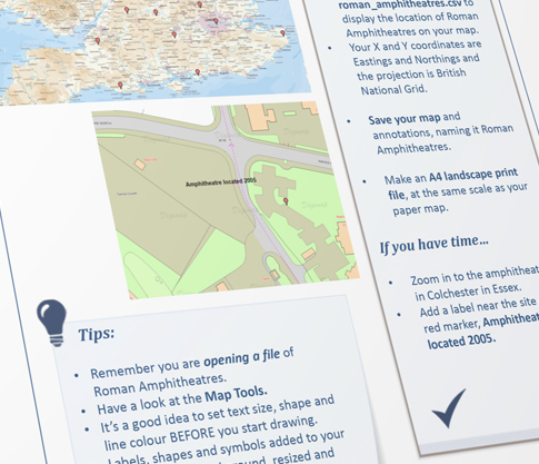
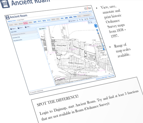
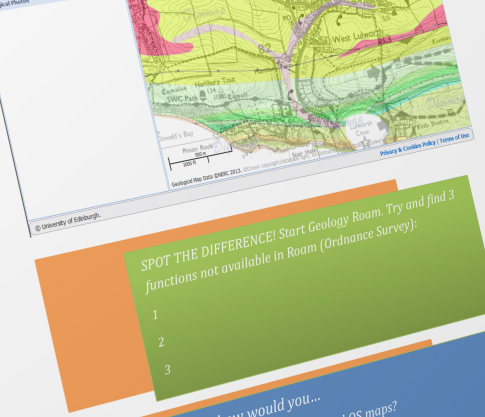
Download suggested workshop plans, accompanying PowerPoint slides and training exercises

  1 hour workshop 2 hour workshop 1 day workshop

Trainer guideHow-to Guides cover the individual functions of a service, for example how to search, save, print...

PowerPoint

Exercises Training Exercises outline a scenario, then provide step-by-step guidance to achieve it.

Resources