
![]()
![]()
![]()
![]()
![]()
The term permeability refers to whether and how water can flow through a rock.
Permeability data is often used in studies of groundwater and in particular during investigations of pollution or aquifer contamination.
The BGS has prepared permeability information based on the 1:50 000 Digital Geological Map of Great Britain (DiGMapGB).
The permeability indices are based on geological considerations and are as follows:
The permeability indices indicate the range of permeability likely to be encountered for each DiGMapGB unit.
The maximum and minimum permeability indices are divided into five classes: very high, high, moderate, low, and very low permeability.
Back to topThis data is available as a national dataset in Shapefile format; there are 4 shapefile,s one for each of the polygon layers in the 1:50,000 data:
It is a very large folder of data and may take some time to download.
The data is based on version 6 of the 1:50,000 geology data; the scale means that it is appropriate to use for regional studies rather than site specific research.
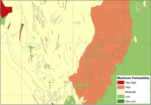
The Permeability Index consists of a three-part code representing: Predominant Flow Mechanism, Maximum Permeability and Minimum Permeability
The Predominant Flow Mechanism code indicates how fluid will migrate from the ground surface through the unsaturated zone of each rock unit and lithology combination and has three classes:
The Maximum Permeability and Minimum Permeability values indicate the range of flow rates likely to be encountered in the unsaturated zone for each rock unit and lithology combination. Five classes are used:
The Maximum and Minimum Permeability values represent a likely permeability range for the specified rock unit and lithology combination at, and immediately below, outcrop (rather than at any significant depth).
The Maximum Permeability represents the fastest potential vertical rate of migration through the unsaturated zone likely to be encountered in the specified rock unit and lithology combination.
The Minimum Permeability represents the minimum, and in some cases more normal, bulk rate of vertical movement likely to be encountered.
Where a widely variable combination of lithologies occurs within a rock unit this value reflects the probable movement rate likely to be encountered in the least permeable horizons.
Back to top
Not found what you are looking for? Please ask a question or give feedback by emailing (digimap@ed.ac.uk) or chatting with the Digimap team.
Share a to this page.
You may also find more information or communicate with us on our Social Media sites:
![]()
![]()
![]()
![]()
| © University of Edinburgh. |