| Data Download Version: | October 2013 |
 |
| Download allowance: | No limit |
|
| Formats Available: | ||
| Version in Roam: | N/A - not displayed in Roam |
|
| View in Roam: | N/A |
|
| Terms of Use: | ||
| Copyright Statement: | © British Crown and OceanWise, 2018. All rights reserved. Licence No. EK001-20180802. Not to be used for Navigation. |
|
| Scale: | 1:250,000 |
|
| Tile Size: | 2 degree tiles (approximately 120x120km) |
|
| Example Uses: |
|
|
| Official Information Sources: | ||
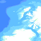
OverviewThe Marine Themes Digital Elevation Model (DEM) is a seabed surface model, comprising detailed and accurate data of the seabed. The dataset utilises the most recent commercial single and multi-beam survey and lidar data available, with chart-derived data providing additional coverage. The 6 arcsecond dataset has a cell size of approximately 180m and can be used to create 3D surface models of the ocean floor. The dataset is available in two degree tiles, which are suitable for use when studying small areas. A 1 arcsecond version is available to download from Digimap which has a cell size of approximately 30m. All depths are to Chart Datum, which in most cases is equal to Low Astronomical Tide (LAT) or Lowest Low Water (LLW) depending on location. For the Marine Themes Digital Elevation Model (DEM) bathymetry data, the data is transformed to Mean Sea level or where appropriate, to a terrestrial datum. |
||
| For
more information about the product see the official User Guide: |
||
Additional Information |
||
| Styling Files: | N/A | |
| Printable Legend: | N/A | |
| Sample Data: | N/A | |