![]()


![]()
OS MasterMap is not a product, it is the framework on which future Ordnance Survey products will be based (the project was initially known as the Digital National Framework or DNF). The central concept of the OS MasterMap framework is the closer relationship between real world objects and features held in the OS spatial database. The Ordnance Survey currently produces four layers of MasterMap data; topography, address, imagery and ITN (roads) layers. Initially two OS MasterMap layers will be delivered by Digimap, the Topography and Integrated Transport Network (ITN) layers.
 In OS MasterMap, topographic features are representations of real-world objects, including buildings, roads, paths, railways, rivers, lakes, ponds, other structures (such as oil storage tanks and pylons), and land parcels. The data also includes non-topographic features such as administrative and electoral boundaries, cartographic text and symbols. All features are represented as points, lines, areas and text, each with attributes that provide additional information relating to that feature.
 OS MasterMap ITN features are representations of physical roads. These features also include the name or number of the road, the road classification and the nature of the road. The ITN layer also includes road routing information such as on-way streets, and junction information.
The data model and structure are fundamentally different from that used in Land-Line. The topographic layer data are sourced from an enhanced version of the OS Topo96 large-scale data from which the Land-Line product is derived. However, the data have been restructured into a seamless database (in contrast to a tiled database as for Land-Line) of approximately 440 million objects. It is fundamentally different from the tile-based Land-Line data. Where possible and desirable, each discrete and identifiable real world object is represented by an OS MasterMap feature.
A significant number of enhancements have been made during the re-engineering of Land-Line to OS MasterMap. A significant departure from Land-Line is the creation of polygons to represent area objects, such as buildings. This adds value to the data and marks a significant improvement over the previously unstructured, unpolygonised data in Land-Line.
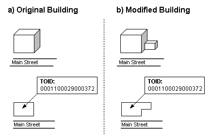
Every OS MasterMap feature has a range of attributes characterising it, building in more descriptive detail and richer attribution than is present in the older product. One of these attributes is always a unique 16 digit integer – the Topographic Object Identifier or TOID. Every OS MasterMap feature has a unique identifier known as a TOID. This is a number that uniquely identifies that feature. TOIDs hold no intelligence; they are allocated sequentially as updates are applied to the database. The TOID will stay the same throughout the life of a feature. OS MasterMap TOIDs have several purposes:
In addition to the TOID, each feature has a version number. The version number is incremented each time there is change of any kind to the feature in the Ordnance Survey database. This means that a feature can be uniquely identified at any stage in what is known as its life cycle. Real-world objects have life cycles. For example, the life cycle of a building might be as follows: it is constructed, it may be extended one or more times, it may eventually be demolished. OS MasterMap features also have life cycles. For example: a new building feature will be created in the data; it may be modified once or more times (to record the changes made to the realm building), and eventually it will be deleted (when the building is demolished). Information about the stage of the life cycle of a feature is provided in the attributes attached to a feature.
Features are grouped into themes such as buildings, roads and land, to enable more flexible data selection by users. Themes should not be thought of as independent data layers, because one feature can be a member of more than one theme. Themes allow a user who is only interested in, say, building footprints, to select just this data.
The themes currently available in the topographic layer are:
OS MasterMap classifies features using feature type, feature description attributes, and feature code. This section is an overview of the function of each of these and the relationships between them.
There are eight types of OS MasterMap feature. For each feature type, a set of feature attributes is defined. The seven types are:
Each feature type has a set of attributes associated with it, for example, the attributes held on a feature of type TopographicLine are:
OS MasterMap features have up to five attributes which make up the description of the feature: descriptiveGroup, descriptiveTerm (optional), physicalLevel, physicalPresence (optional), and make (optional). A combination of these attributes can be used to determine the appropriate representation and symbology to use when displaying the data. The information conveyed by each of these attributes is as follows:
|
Value |
Description |
|---|---|
|
Landform |
Features representing, describing or limiting areas of landform. For example, slopes or cliffs. |
|
Terrain And Height |
Features giving information about the altitude at a location or changes of level of the ground surface. |
|
Tidal Water |
Features representing, describing or limiting areas of water that are tidal. |
|
Roadside |
Features representing, describing or limiting the extents of roadside detail. |
|
Inland Water |
Features representing, describing or limiting areas of water that are not tidal. |
|
Buildings Or Structure |
Text features describing or naming buildings and structures. |
|
Building |
Features representing buildings (not including glasshouses). |
|
Glasshouse |
Features representing glasshouses. |
|
Structure |
Features representing, describing or limiting structures other than buildings or glasshouses. |
|
General Surface |
Features representing, describing or limiting areas of land not covered by buildings or structures. |
|
General Feature |
General topographic features and minor detail. |
|
Road Or Track |
Features representing, describing or limiting the extents of roadways and tracks. |
|
Path |
Features representing and limiting the extent of pathways |
|
Rail |
Features representing, describing or limiting the extents of railways. |
|
Historic Interest |
Features of heritage value. |
|
Political Or Administrative |
Features representing political or electoral boundaries. |
|
Height Control |
Features with height information. |
|
Network Or Polygon Closing Geometry |
Features used to close polygons. |
|
Natural Environment |
Features representing geographic areas and extents of natural environments and terrain. |
|
Built Environment |
Geographic areas and extents of man-made environments, terrain and communication links. |
|
Unclassified Topographic |
Features that have not been given a description yet. |
The OS MasterMap ITN Layer is currently composed of two themes – Roads and Road Routing Information. This may be expanded in the future to include rail, water, track and path themes.
The Roads theme consists of a fully topologically structured link and node network representing the driveable roads of Great Britain.
The following features are included in the Roads theme:
The product contains the following information:
RRI is information about a route that may affect a driver’s choice of route. It could be either restriction information such as a prohibited turn of one-way street, or advisory information such as the presence of a ford.
Within ITN, routing information is maintained as separate features from the base network information, but these features reference the underlying road network features to provide their location.
OS MasterMap is supplied in geography Markup Language (GML). GML is an international standard for storing and transporting geographical information developed by the OpenGIS Consortium (OGC). This is an open standard, based on XML, compatible with a host of web-based technologies and encourages interoperability. It has been chosen as the data supply method in place of traditional transfer formats for a variety of reasons. The main reasons may be summarised as follows:
Not found what you are looking for? Please ask a question or give feedback by emailing (digimap@ed.ac.uk) or chatting with the Digimap team.
Share a to this page.
You may also find more information or communicate with us on our Social Media sites:
|
© University of Edinburgh. |