![]()


![]()
These notes provide guidance on the appearance of maps created from Land-Form PROFILE Contours and guidance on the Contour and Digital Terrain Model (DTM) versions of the Land-Form PROFILE data. Ordnance Survey produce a User Guide for these products which can be downloaded from here. The User Guide also includes details on the use of NTF and DXF to supply the data.
Land-Form PROFILE Contours have been created from a 1:10,000 scale Ordnance Survey Mapping. In turn, the Land-Form PROFILE Digital Terrain Model (DTM) has been mathematically generated from the Contours dataset. They are each very different ways of presenting height information. These guidance notes are therefore structured into two separate sections, one for Contours, and one for DTM.
All heights in Land-Form PROFILE are given in metres above mean sea level (or more precisely, above Ordnance Survey's reference datum, which was mean sea level at Newlyn in Cornwall measured from 1 May 1915 to 30 April 1921).
The Land-Form PROFILE products are updated annually.
Land-Form PROFILE Contours contain line features and point features.
The line features depict the following:
The point features depict the following:
Instances of each feature type carry a numeric attribute giving a height value to a resolution of 1 cm. In the case of Coastline this height is 0m. Some Form Lines in low-lying terrain (for instance in Norfolk) have negative values.
Land-Form PROFILE Contours contain no cartographic text (i.e. text designed for display on screen). The height attribute associated with each feature can be used for display purposes.
Digital contour accuracy values are typically better than half the contour interval, that is ±2.5 metres for areas with 5 metre vertical intervals and ±5 metres for areas with 10 metre vertical intervals.
Spot heights are recorded to the nearest 0.1 metre.
Air heights and some supplementary spot heights are recorded to the nearest 1.0 metre.
The Land-Form PROFILE Contour data contains six feature types. Each of these is given a Feature Code which in NTF data is a text string made up of four digits. Features codes, or layer names, in Land-Form PROFILE Contour DXF data, are prefixed by the characters "G802". For more information on DXF data download the user guide. The complete list of Feature Codes for Contour data and a description of what they refer to is given here:
| Feature Code | Description | Type | Attributes | Notes |
|---|---|---|---|---|
| 1372 | Air Height | Point | HT | Height measured at a given point, using photogrammetric techniques. Air Heights are usually located at the top of hills, where Spot Heights do not exist. |
| 0027 | Spot Heights | Point | HT | Height measured at a given point, from ground survey. Spot Heights are usually located at the top of hills. |
| 1361 | Index Contours | Line | HT | when vertical interval of standard contours is 5 metres, index contours are at multiples of 25 metres. When vertical interval is 10 metres, index contours are at multiples of 50 metres. |
| 0075 | Standard Contours | Line | HT | At 5 metre vertical intervals, except in mountain and moorland areas where the vertical interval is 10 metres |
| 0071 | High Water Level Tide Line | Line | HT | Mean High Water along coast, including tidal estuaries. |
| 0072 | Low Water Level Tide Line | Line | HT | Mean Low Water along coast, including tidal estuaries. |
| 0059 | Water | No features with this feature code appear in the PROFILE dataset |
The attribute code used above is detailed in the table below.
| Code | Description | Notes |
|---|---|---|
| HT | Height | Height of feature in metres. |
Spot Heights
Heighted points captured by ground methods. They are normally positioned along the centre of roads.
Air Heights
Heighted points captured by photogrammetric methods at the same time as the contours. They are normally shown in the following positions:
Contours are depicted as two dimensional lines, with the HT attribute giving the contour's height in metres.
The Standard Contours are at a vertical interval of 5 metres (With an Index Contour every 25 metres), except in "mountain" or "moorland" areas where the vertical interval is 10 metres (with an Index Contour every 50 metres. The same vertical interval is applied to an entire Ordnance Survey map tile. Therefore a tile will include 10 metre intervals, or 5 metre intervals, but will not include both. Where a map tile containing 5 metre vertical intervals meets a map tile containing 10 metre vertical intervals, alternate 5 metre contours will end abruptly at the tile boundary, as shown in the following image of Land-Form PROFILE tiles SH90SE and SJ00SW:
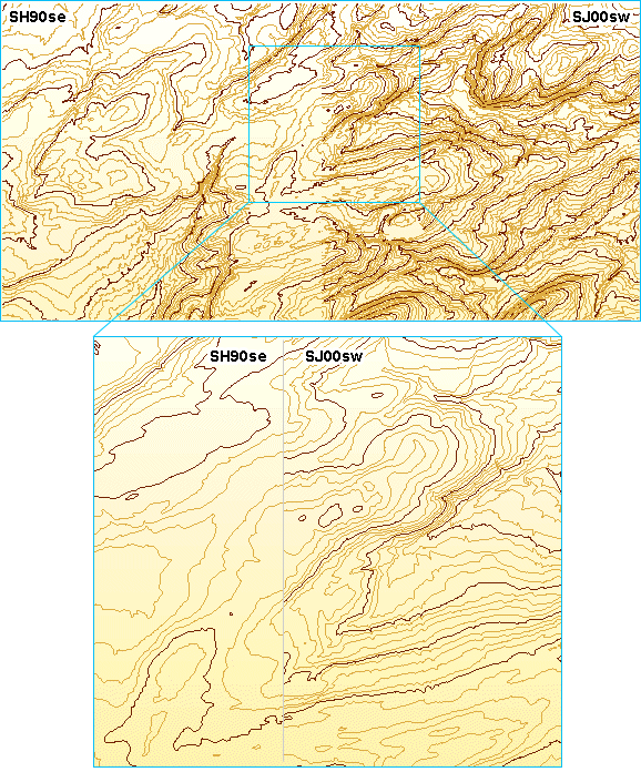
Tile SH90SE, on the left, has contours with 10 metre vertical intervals because all or part of the geographical area covered by the tile includes "mountain" or "moorland" areas. Tile SJ00SW, on the right, contains no "mountain" or "moorland" areas and so has contours with 5 metre vertical intervals.
This lack of edge matching of contours across tile boundaries is not an error in the data but the result of a data capture and formatting decision made by the Ordnance Survey.
Contours in Land-Form PROFILE are also discontinuous in some locations for the following reasons:
Tide lines include both high water marks and low water marks. In England and Wales these represent high and low marks of a mean tide, which is an average tide halfway between spring and neap tides. In Scotland the high and low water marks are of average spring tides. A Tidal Line will cross tidal rivers at the point to which mean tides (England and Wales) or spring tides (Scotland) flow at high water (known as the Normal Tidal Limit).
Although a "Water" feature code [0059] appears in the NTF file header information for Land-Form PROFILE Contour data, the feature does not appear anywhere within the dataset. Thus, when viewing the PROFILE Contours in a GIS, a "Water" feature layer may be present, though there will be no features within it to display.
Land-Form PROFILE Digital Terrain Model (DTM) contains height information only. It does not contain a representation of the Spot Heights, High and Low Water Marks or other features that are represented in Land-Form PROFILE Contours.
Heights are given at the intersections of a horizontal 10 metre grid. These values have been mathematically interpolated from the same set of features that are represented in Land-Form PROFILE Contours. The results achieved will depend on the density of height data contained in the contour file.
In some flat areas where there is little height information, contours and spot heights may be a great distance apart. This can cause irregularities in the DTM which appear as slight terracing of the terrain.
The height accuracy of any point in the DTM is equal to or better than half the contour interval. that is ±2.5 metres for areas with 5 metre vertical intervals and ±5 metres for areas with 10 metre vertical intervals.
Not found what you are looking for? Please ask a question or give feedback by emailing (digimap@ed.ac.uk) or chatting with the Digimap team.
Share a to this page.
You may also find more information or communicate with us on our Social Media sites:
|
© University of Edinburgh. |