Abandoned Agricultural Land - Case Study
Research title
The abandoned agricultural land of North west Scotland: the potential contribution towards a sustainable future.
Author
Angus Leigh.
Project type
MSc dissertation.
Subject
Soils and sustainability.
Related subjects
History; Agriculture; Soils Science; Geosciences.
Datasets
Getmapping Plc Aerial Imagery.
- Source: Aerial Digimap.
- Dates/editions: Latest available.
- Scale: 25cm resolution.
Publishing Institution
University of Edinburgh.
Summary
In North West Scotland there are considerable tracts of land that once produced a wide range of crops and supported a large population. Today this land is invariably used simply as rough grazing and many of the townships and villages are uninhabited. This study examined the potential of bringing the historic cultivated land back into production, not just to meet demands for food security but also to fulfil its role within the wider ecosystem. A means of quantifying the land was developed and tested to provide figures that can guide policy. Soil quality and land capability is assessed at a variety of different locations to determine if it retains the potential it once had. The research reveals there could be tens of thousands of hectares of historic cultivated land in NW Scotland and that a significant proportion is suitable for crop production.
Aims & Objectives
- Establish a method for identification and quantification of historic cultivated land using GIS and aerial imagery
- Test that method through application to a limited area of north west Scotland and validate the process by ‘ground truthing’ at selected sites
- Establish a set of procedures, with reference to established techniques, that include sufficient parameters to judge the quality and capability of historic cultivated land
- Using these procedures, carry out fieldwork at selected sites to assess the land and to collect soil samples for subsequent laboratory analysis
- Review the results to assess the effectiveness of the procedures employed and to determine the quality of the soil and the capability of the sites for reactivation
- In light of these results, investigate the potential contribution historic cultivated land can make towards a sustainable future
Methodology
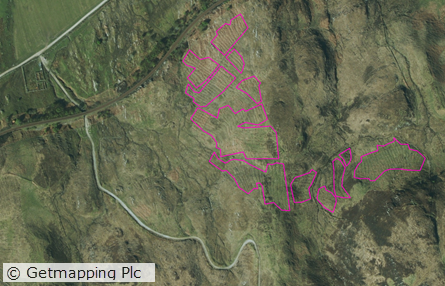
The past techniques for cultivation required the formation of raised soil beds, variously described as ‘lazy beds’, run rig, and rig and furrow, to provide a suitable environment in which crops could grow. Despite having been abandoned for 60 years or more, the distinct profile of these remain quite clearly visible at ground level and particularly from the air. The availability of high quality aerial imagery now provides an opportunity to identify this land without the need for intensive ground surveys. Furthermore, as the imagery is georeferenced, it can be quantified using GIS. Identification and quantification is an essential first step in assessing if this land holds potential for the production of crops once again.
Site visits were carried out to ensure the sites of historic cultivated land had been correctly identified, an important process given that the rig and furrow could be confused with old peat cuttings, turf stripping, drainage improvements and even rows of newly cut hay. This highlighted the need for high quality imagery in order to easily differentiate between the different land uses and to therefore accurately quantify the historic cultivated land itself.
Results/outcome
In every case, the historic cultivated land was identified correctly as a result of the fine detail of the imagery. This also meant it was possible to digitise the boundaries of each tract of land with a high degree of accuracy and therefore produce a precise figure for the overall area of land being studied. Having access to the imagery was particularly convenient in light of the extent of the geographical area under consideration.
It was not possible to quantify the historic cultivated land for the whole of the Crofting Counties due to time constraints but it was possible to do so for a smaller selected area. It allowed the establishment of a procedure that was proven on a small scale and could be scaled up in the future. The process not only quantifies the overall amount of historic cultivated land in the area under review but also provides information such as the total number of tracts and their individual areas. Particularly beneficial is the ability to categorise the land according to its potential and to store this data within the GIS database, to be accessed in the future perhaps to assist with policy making for local development or for land management purposes. Based on the information gained during site visits to assess the soil and site conditions it appears likely that the aerial imagery is of suitable quality to allow fairly reliable categorisation using desk based research alone.
Sample map