Public Health - Case Study
Research title
Home and work neighbourhood influences on physical activity within West Central Scotland.
Author
Laura Macdonald is a Research Assistant within the Neighbourhoods and Communities Programme at the Social and Public Health Sciences Unit at the University of Glasgow. More information about her current projects can be found here.
Project type
Dissertation.
Subject
Public Health.
Related subjects
Social Sciences, Public Health, GIS, sports facilities, physical activity, built environment.
Datasets
OS MasterMap® Integrated Transport Network Layer - Sourced from Digimap Collections, Scale 1:1250, 2011 edition.
Publishing Institution
MRC/CSO Social and Public Health Sciences Unit (SPHSU), University of Glasgow
Abstract
Engaging in a sedentary lifestyle has been associated with poor health and shortened lifespan, nonetheless over one third of the Scottish population do not meet recommended exercise levels. Existing research investigating exercise determinants explored associations with built environment features; much of this research focused on activity spaces around home, and did not acknowledge the potential for workplace neighbourhoods to play a significant role in exercise behaviour.
This research made use of an existing West Central Scotland survey dataset (THAW 2010), and publically available built environment data to explore whether, for working adults, there was an association between physical activity frequency and a supportive physical activity environment within either home neighbourhoods or work neighbourhoods.
Aims & Objectives
Main research question - Are people living/working in areas with better spatial access to physical activity facilities more active than those living/working in poorer access areas?
Methodology
Used GIS software to map home and work postcodes and geographical co-ordinates of exercise facilities, such as gyms, pools, tennis courts, football pitches etc. Created neighbourhood buffers around home postcodes and work postcodes. Quantified spatial access to sports facilities e.g. numbers of facilities within buffers and distance to nearest facility, at home and at work. Used statistical software to explore associations between self-reported physical activity and access to facilities within home and work areas.
Use of dataset
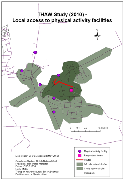
The OS Integrated Transport Network (ITN) layer, available through the Digimap service, was used. The ITN layer was used within GIS software to create half mile and one mile network buffers (i.e. defined distance along road/path networks in all possible directions away from a point with route ends joining to form enclosed areas) around home and work postcodes. The ITN layer was also used to calculate the distance between home and work postcodes and the nearest sports facility. See figure for example of network buffers and route from a study respondent location to their nearest facility.
Sample map
Results
A paper related to this project was published in 2019.
References & Acknowledgements
MSc funding was provided by the MRC/CSO SPHSU and the course was run by the University of Southampton Geography and Environment Department. Study data was obtained from THAW 2010 and facility data from SportScotland.