![]()


![]()
AuthorDavid Waterhouse |
DateJanuary 2007–April 2007 |
||||||||||||||||||||||||||||||||||||||||
Project TypeUndergraduate dissertation |
SubjectGeography, Transport |
||||||||||||||||||||||||||||||||||||||||
DatasetsOS County series from 1845-present Sources: Digimap, UK Data Service Census Support (formerly UKBORDERS) Dates/Editions: First Edition, First Revision, Second Revision and Third Revision Scales: 1:10,560, 1:25000 |
Related SubjectsUrbanisation, Geography and Historical Geography
|
||||||||||||||||||||||||||||||||||||||||
Key WordsTransport, Urbanisation, Sheffield |
|||||||||||||||||||||||||||||||||||||||||
Publishing InstitutionDepartment of Architecture and Planning, Geography, Sheffield Hallam University |
|||||||||||||||||||||||||||||||||||||||||
SummaryTransport is essential to movement within urban areas. This study looks at how the development transport networks influence the development of urban areas. Using the literature within this field and the cutting edge technique of digital mapping, the urban development of Sheffield will be studied to see whether the development of the transport networks, road and rail, influenced the development of the urban area of Sheffield. The mapping aspect of this study will historical mapping from 1850, as this is the earliest date that these maps are available. This will demonstrate what has occurred in Sheffield in terms of urbanisation and transport network development. |
|||||||||||||||||||||||||||||||||||||||||
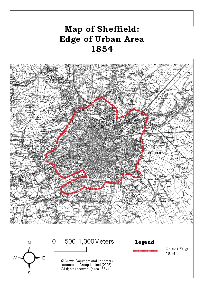
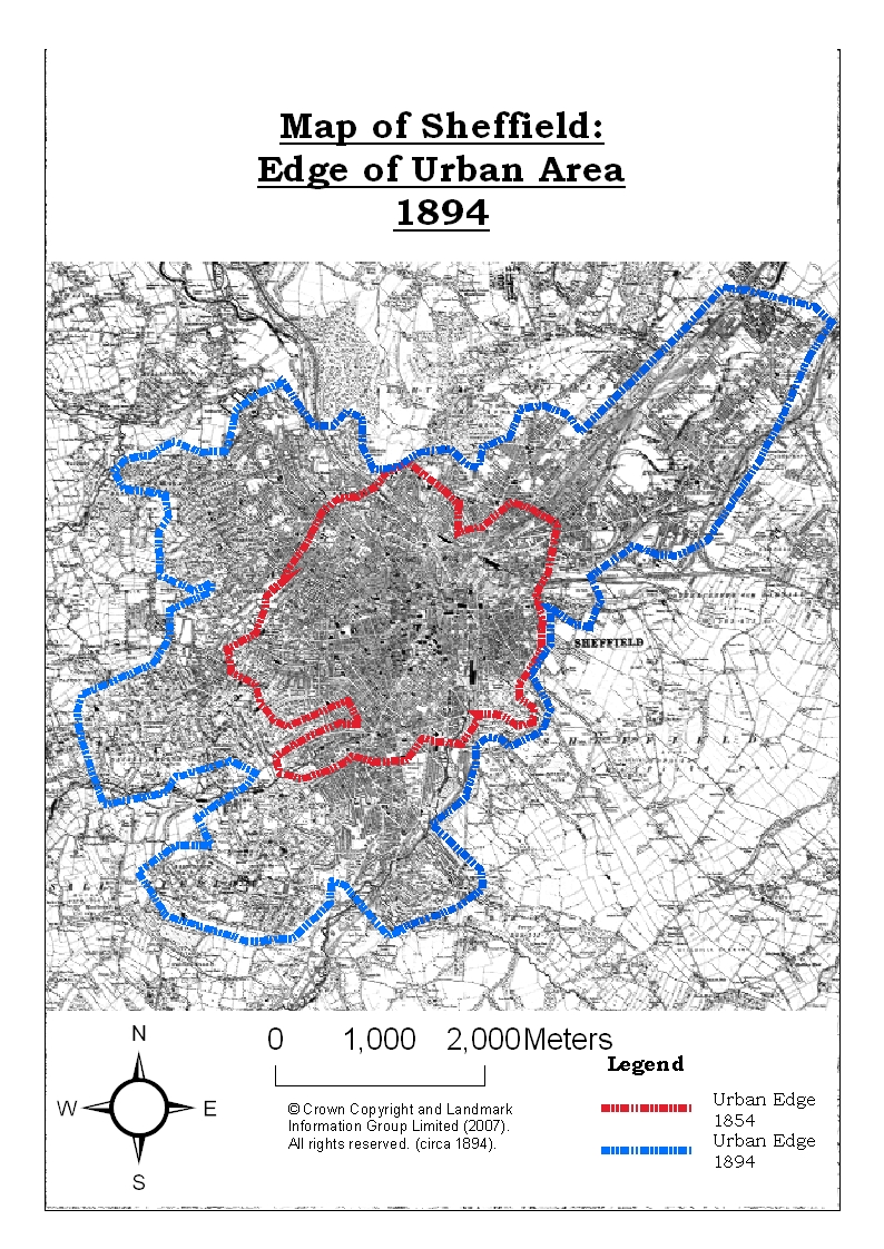
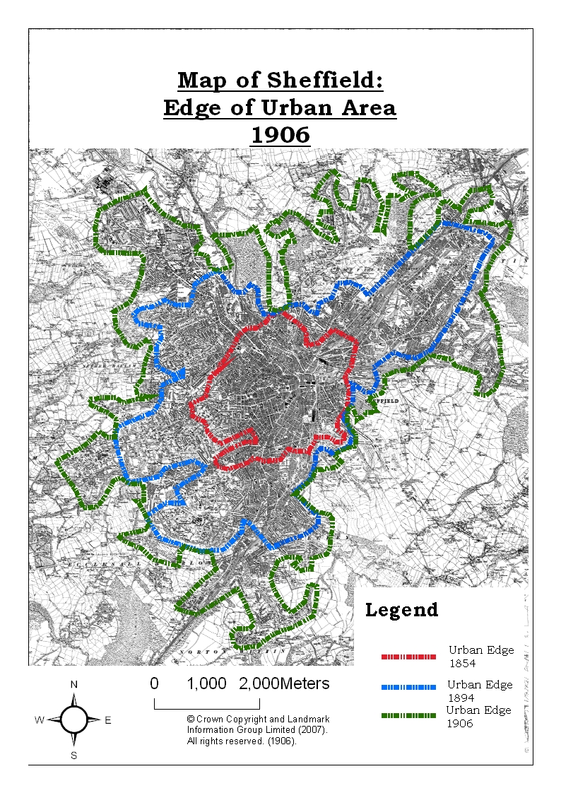
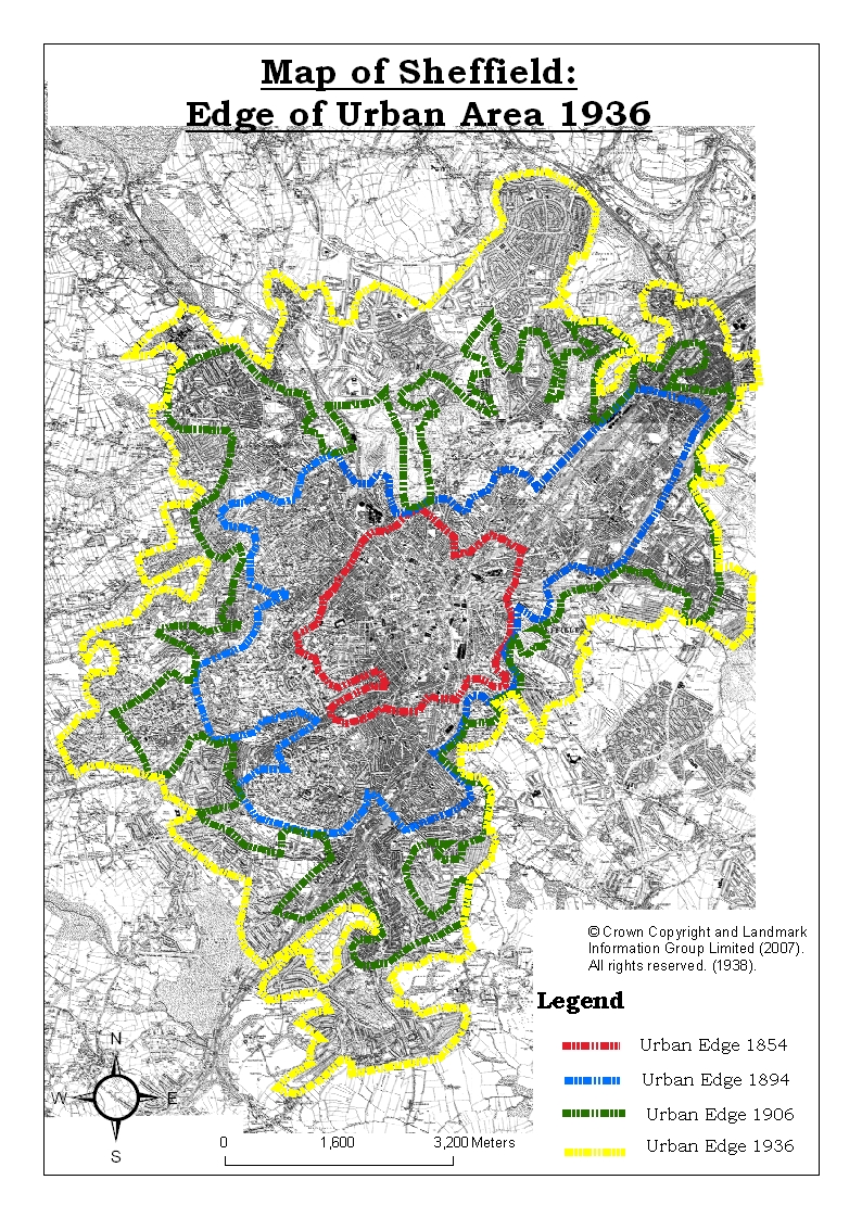
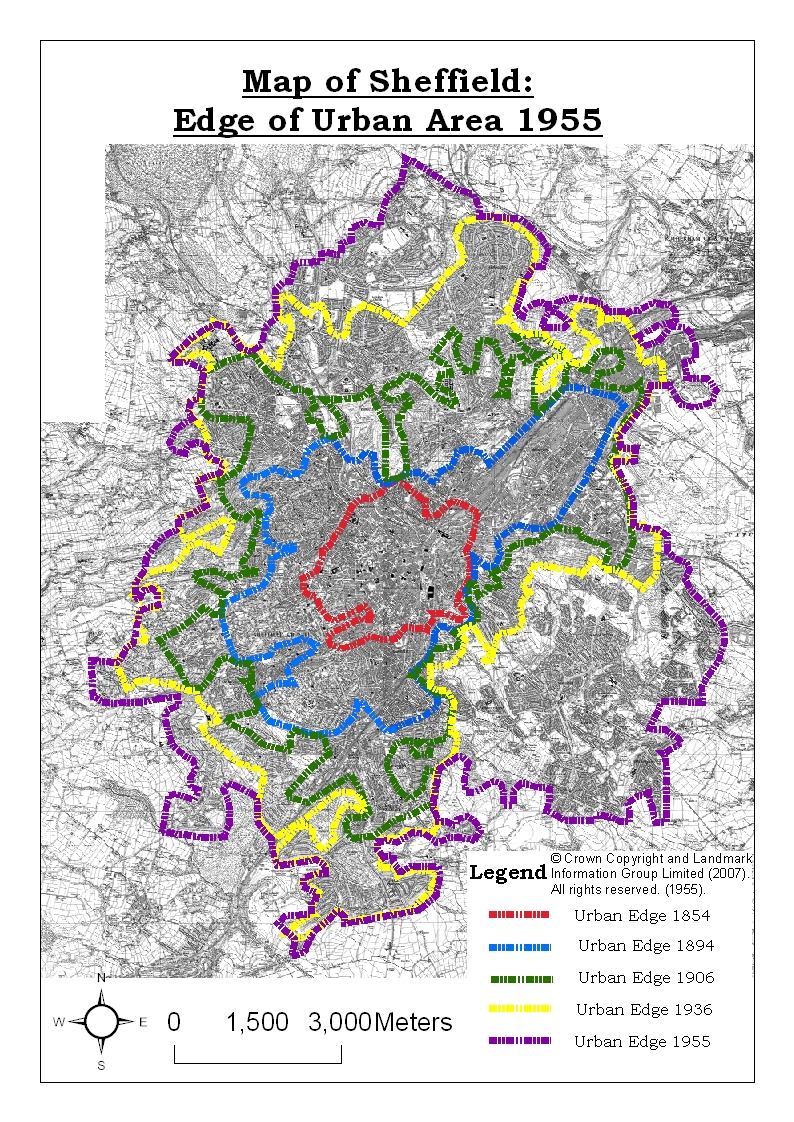
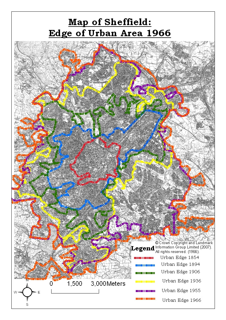
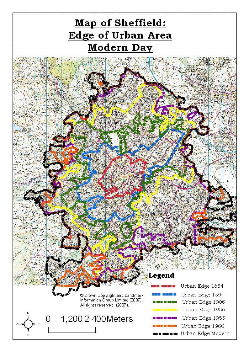
Methodology and ResultsUsing historical mapping to look at where and when Sheffield urbanised and how the transport networks were developed. Initial empirical studies looked at Sheffield in determining what has taken place in terms of urbanisation and transport network development. The first set of maps show the urban area of Sheffield in the 1850’s up to the modern day. The following set of maps show the transport networks in Sheffield during this period. Historical mapping will help to show what had taken place and where it had taken place in terms of urban development and transport network development. In this, identifying the changes in roads (trams are considered under this due to difficulties in mapping them individually), railway lines and railway stations are key. The final maps show the urban area of Sheffield and the transport routes, to see whether urban development allowed transport to develop or the development in the transport network allowed urbanisation to occur since 1850. These maps will be manipulated to show the urban fringe of Sheffield over the years and the transport networks and how they have developed since 1850. Bagwell and Lyth (2002) argue that urban transport is central to urbanisation because of life in cities is structured around constant movement of people and goods. However another discourse proposed by Smith-Morris (1997) suggests that the Industrial Revolution was the main influence for urban development because of it provided a cause and effect relationship with the British towns and countryside. In turn this would lead to the need for transport. The urban sprawl and the intensity of the transport networks that Sheffield has now compared to what it once did illustrates the development, of both urban area and the transport networks, that has occurred since 1850. On the 1894 map the north-east area of Sheffield experienced significant expansion from the 1854 map. Also this area of Sheffield had increased numbers of railway lines. The differences, shown in red on the map, from the 1854 map are two lines that branch out into at least two other lines from the Manchester, Sheffield and Lincolnshire line. As there is no maps available between 1854 and 1894 it is difficult to determine whether transport development influenced the urban development here, but as this area is where the industrial area of Sheffield was it is likely that this area developed because it was near a railway line and the new lines were as result of the further urban development. This backs the discourse that the Industrial Revolution influenced urbanisation and the development of the transport network. This evidence also suggests that urbanisation and transport development are processes reliant upon each other. Other changes to the rail network were also quite significant. Sheffield now had two central stations and a new line to the south, which split into two - rail links to London & Birmingham. The streets in the centre of Sheffield appear to have been widened, but the roads coming from the outside of Sheffield remained virtually the same. Therefore it is understandable that industrial areas of urban areas developed because of the railway during the late nineteenth century. This is the most likely cause in the case of Sheffield. In the 1906 map most the development that had taken place in Sheffield was to the west, few roads here, so this cannot be an attributing factor. In fact the only development was a rail-line north-east of Sheffield at this time. But, This area is easily accessible for the coal mines of South Yorkshire, which would provide the fuel for the industry there especially the steel industry, which Sheffield is famous for. Maps in 1936, in the middle of the inter-war period, again shows little development in the transport network or in the urban area. It appears industry has had the greatest influence over urbanisation and transport network in this period. In the 1966 map the urban area of Sheffield slightly grew and the only change to the transport network was the closure of one of the two central stations. From the evidence in the last maps, it seems that the development of the transport network has allowed urbanisation to take place, but this urbanisation has taken place several decades after the network has been there. Modern maps support this too - The map has the clearest roads, which have been highlighted in pink or blue. Some follow existing routes but others have been built to service areas of Sheffield that are far away from the city centre. This suggests the transport network developed as a result of urbanisation. The Hoyt urban model is probably the best description of Sheffield. Results indicate that both transport network development and urbanisation to be inter-linked processes, each depending upon one another. |
|||||||||||||||||||||||||||||||||||||||||
Images
|
|||||||||||||||||||||||||||||||||||||||||
Acknowledgements and ReferencesSupervisor - Josie Wilson and lecturers Frank Brown, Russ Haywood, Keith Mckoy, Camilla Bassi, Larissa Davies, and Neil Pritchard at Sheffield Hallam University. References
|
|||||||||||||||||||||||||||||||||||||||||
Not found what you are looking for? Please ask a question or give feedback by emailing (digimap@ed.ac.uk) or chatting with the Digimap team.
Share a to this page.
You may also find more information or communicate with us on our Social Media sites:
|
© University of Edinburgh. |