![]()


![]()
|
|
AuthorDr Kiril Stanilov |
Date2011-2012 |
|
Project TypeResearch |
SubjectGeography |
|
DatasetsHistorical County Series 1856-1969 National Grid 1943-1996 OS MasterMap
Sources: Digimap Dates/Editions: County Series – 1st Edition, 1st, 2nd, and 3rd Revisions; National Grid - 1st Edition, 1st Revision Scales: 1:10,650, 1:10,000 |
Related SubjectsTown Planning; Urban Modelling; History; Transportation |
|
Key wordsTransportation; Networks; 17th century; 18th century; 19th century; urban expansion; London |
||
Publishing Institution |
||
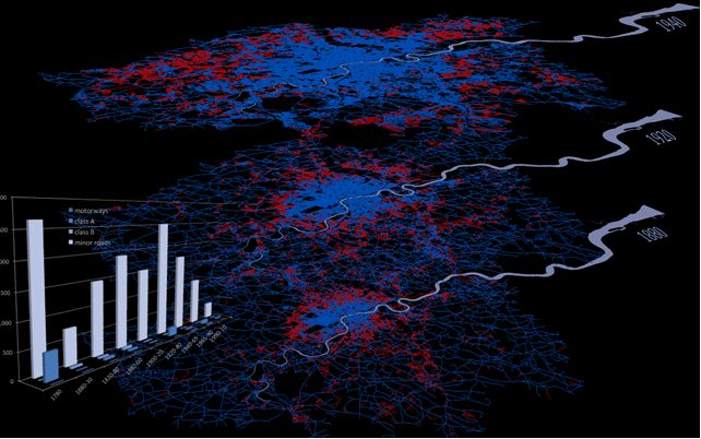
SummaryWe reconstructed the expansion of the transport networks (road, rail and water) in Greater London from the late 1700s to the present. |
||
Aims & ObjectivesThe project findings serve as a basis for the development of rules describing the logic underlying the evolution of transport networks in urban models. Such models can predict with greater accuracy what the spatial behaviour of the transport systems will be on the basis of known structural properties. |
||
MethodologyWe used OS historical maps to document the evolution of the road and rail networks in time series, generating snapshots of the networks in roughly 20-year increments. This longitudinal database was then used to perform a network analysis of the statistical properties of the road infrastructure system characterising its spatial behaviour over time. |
||
Results/OutcomeResearch is ongoing, and details will be updated on the project website as they become available. |
||
References & AcknowledgementsThe project was carried out under the umbrella of the GENeSIS project funded by ESRC.
Image © Copyright Kiril Stanilov, 2012 |
||
Not found what you are looking for? Please ask a question or give feedback by emailing (digimap@ed.ac.uk) or chatting with the Digimap team.
Share a to this page.
You may also find more information or communicate with us on our Social Media sites:
|
© University of Edinburgh. |