![]()


![]()
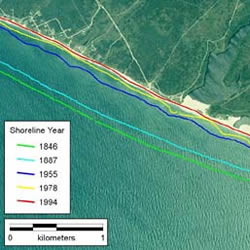
Image from Thieler, E. R., Martin, D., and Ergul, A., 2003. The Digital Shoreline Analysis System, version 2.0: Shoreline change measurement software extension for ArcView. USGS Open-File Report 03-076.
AuthorDr Sally Brown |
Date2008 |
Project TypePhD |
SubjectCoastal Engineering |
DatasetsOS County Series and National Grid; Land-Line.Plus; Aerial photographs; DGPS (Differential Global Positioning System) survey data of cliff top position Sources: Digimap; East Riding of Yorkshire Council Dates/Editions: All available. Scales: 1:10,560 & 1:10,000, but 1:2500 also used. |
Related SubjectsGeography; Coastal Studies |
Key WordsEngineering |
|
Publishing InstitutionSchool of Civil Engineering and the Environment, University of Southampton |
|
SummaryCoastal defences reduce sediment input and modify the sediment budget, usually resulting in a sediment deficit down-drift and an accumulation up-drift. This process results in set-back adjacent to defences. Three types of set-back were identified and these occur due to the: • terminal groyne effect, where defences stop or dramatically reduce erosion, induce a sediment deficit down-drift and cause an increase in retreat rate; • perceived terminal groyne effect, where defences stop or dramatically reduce erosion, and down-drift retreat rates remain the same or decrease; • initial groyne effect, where defences stop or dramatically reduce erosion, induce sediment accumulation up-drift and cause a decrease in retreat rate. Set-backs are found on defended coasts world-wide, and are complex evolving features dependent on numerous natural and anthropogenic factors. 200 set-back sites were identified in England and Wales, half on cliffed coasts. The terminal groyne effect theory was investigated on 17 sites on the soft cliffs of Holderness, Christchurch Bay and north-east Norfolk, UK, all of which erode naturally at 0.5m/yr-2.0m/yr. Historical shoreline analysis and a history of human intervention was undertaken for each study region and site. For 13 out of the 17 case studies, a terminal groyne effect appeared to have occurred. As time passed and the magnitude of set-back increased, the terminal groyne effect became increasingly apparent. Where increased retreat resulted, the coast was affected for tens to thousands of metres down-drift. For the remaining case studies, a perceived terminal groyne effect occurred. An initial terminal groyne effect occurred at all sites. Longshore, the continued set-back caused outflanking of defences prompting emergency works, such as repeated defence extensions up and down-drift. Over several decades of set-back, the defences formed an artificial headland and created a crenulate shaped embayment down-drift. The planform of an embayment expanded rapidly, then reduced to a steadier retreat rate. As shoreline management evolves from a highly defended to a less heavily managed coast, defence abandonment will result in rapid retreat. Set-backs may be created due to the juxtaposition of maintained and abandoned defences, as illustrated at Happisburgh, Norfolk. In the coming decades, set-backs, artificial headlands and the terminal groyne effect will remain important issues for shoreline management. |
|
MethodologyLand-line data was downloaded from Digimap to create a base map on GIS (ArcView 3.2) for each study site. Digimap was used to download historical maps (1:10,560 or 1:10,000, and 1:2500) from 1854 to the present day. To document a history of coastal defence for each study site, the historical maps were added to the GIS, together with aerial photographs. Additions and changes to the defences were documented, including the type of defence, location and length of defences. The cliff top position on each map or photograph was traced onto the GIS, together with DGPS surveys undertaken. To calculate cliff top retreat, Thieler’s et al (2003) Digital Shoreline Analysis System (DSAS) was used to cast transects from a baseline across the historical cliff lines. The retreat was measured and referenced to the oldest cliff line. Data was transferred from ArcView 3.2 to Excel and retreat rates before and after coastal defence construction were calculated and compared |
|
Results/OutcomeBrown, Sally (2008). Soft cliff retreat adjacent to coastal defences, with particular reference to Holderness and Christchurch Bay, UK. University of Southampton, School of Civil Engineering and the Environment, Doctoral Thesis, 333pp. A PDF of this research can be downloaded here. |
|
References & AcknowledgementsSupervisors: School of Civil Engineering and the Environment, University of Southampton – funded via an EPSRC studentship supervised by Professor Robert Nicholls and Dr Max Barton.Additional data and support was provided by East Riding of Yorkshire Council. Thieler, E. R., Martin, D., and Ergul, A., 2003. The Digital Shoreline Analysis System, version 2.0: Shoreline change measurement software extension for ArcView. USGS Open-File Report 03-076. Accessed on 2nd October 2006. |
|
Other InformationDr Sally Brown is now a Research Fellow at the University of Southampton. More information about her current research projects can be found here. |
|
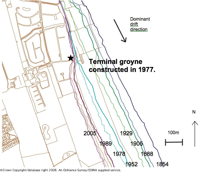
Historic cliff top positions at Hornsea, Holderness. The coastline continues to retreat after defence construction, with retreat rates increasing. The star indicates the location where the photograph below was taken. 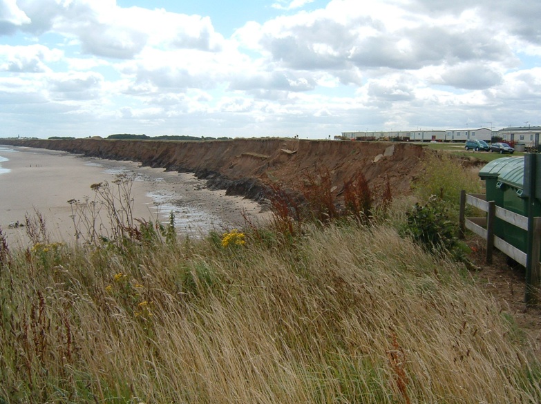
Cliff retreat down drift of defences at Hornsea. Photograph taken on 9th August 2006. |
|
Not found what you are looking for? Please ask a question or give feedback by emailing (digimap@ed.ac.uk) or chatting with the Digimap team.
Share a to this page.
You may also find more information or communicate with us on our Social Media sites:
|
© University of Edinburgh. |