In this Topic Hide
Remember that the information provided here is only a guide. You must check what citation style you are required to follow, e.g. Harvard System, and ensure your citation meets those requirements.
The main focus of your citation should be to ensure that the user of the citation can access the same data that was originally used where possible, or will have an understanding of what data was used and how to access it.
A Digimap user, Claire Smith, prints a large-scale map of Durham Cathedral from Ordnance Survey Roam. Claire enters a title on the map print, "Durham Cathedral".
She plans to include the print in an essay and needs to provide a citation.
We recommend the following form:
Smith, Claire, “Durham Cathedral”, PDF map, Scale 1:2500, OS MasterMap, May 2019, Ordnance Survey, using Digimap Ordnance Survey Collection, https://digimap.edina.ac.uk/, created 26 June 2019.
We recommend incorporating the fields in the table below. We detail where in Roam, or on your map print, you can find the information.
| Field | Example
|
Where to find the information |
| Author | Claire Smith |
your name |
| Map title | Durham Cathedral | any title you have given to your map |
| Map format | e.g. PDF map, PNG map | check the file format on your device |
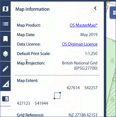
| Scale | 1:1250 | provided on your map print, or in the Map Information area, field Scale |
| Map data product(s) name* | OS MasterMap® | Map Information area, field 'Map Product' |
| Map data product(s) date* | May 2019 | Map Information area, field 'Map Date' |
| Map data producer* | Ordnance Survey | If you're not sure who provides the data for a Digimap Collection, check the About and Data areas on the Digimap Collections page. |
| Service used | Digimap Ordnance Survey Collection | |
| URL of service | https://digimap.edina.ac.uk | |
| Date created, downloaded or accessed | 26 June 2019 | Date and time of map provided on map print |
*You will need to repeat the map product information if your map uses more than one mapping data product.
In the sidebar in Roam. Select the information icon to open it.

A user, Joe Bloggs, downloads two different types of map data from Geology Digimap. He combines the data with data he collected in the field to create a map, using ArcGIS online.
He needs to cite each map product he used. He can find the required information with his download file.
• A text file is provided within your data download file from Digimap.
• It will be called citations_orders_******.txt.
• We've circled an example in the image below.

A citation is provided for each mapping product you have downloaded. Heres an example of one for the 1:50000 scale onshore geology data:
DiGMapGB-50 [SHAPE geospatial data], Scale 1:50000, Tiles: ew328,ew329,ew341_342_343, Updated: 30 November 2016, BGS, Using: EDINA Geology Digimap Service, <https://digimap.edina.ac.uk>, Downloaded: 2019-09-25 13:18:02.607
The citation includes:
• Mapping product name (and format)
• Scale
• Tiles ordered - if this is a very long list, you can remove them and just provide an area
• Update date for data
• Provider
• Source
• Date downloaded
Each Digimap Collection offers a service where users can access map images from Digimap by adding our Web Map Service to their own software.
OS VectorMap™ District [WMS web map service], North Yorkshire, updated November 2017, Ordnance Survey, using: Digimap Ordnance Survey Web Map Service, <https://digimap.edina.ac.uk/, accessed 11 June 2019.
We recommend including:
• Map data product name [web map service],
• Coverage: name the geographic area or provide geographic coordinates
• Update date of data - the update version for the whole dataset is sufficient, rather than the update date of individual tiles
• Producer e.g. Ordnance Survey, British Geological Survey etc.
• Using: EDINA Digimap Ordnance Survey Service, <http://edina.ac.uk/digimap>,
• Date accessed