![]()


![]()
| Data Download Version | June 2020 |
 |
| Download allowance: | 100 tiles |
|
| Formats Available: | ||
| Version in Roam: | December 2019 |
|
| View in Roam: | Neighbourhood View |
|
| Terms of Use: | ||
| Copyright Statement: | © Crown copyright and database rights 2020 Ordnance Survey (100025252) |
|
| Scale: | 1:25,000 |
|
| Tile Size: | 10 x 10km |
|
| Example Uses: |
|
|
| Official Information Sources: |
|
|
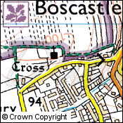
Overview1:25,000 Colour Raster data, as its name suggests, is a raster dataset. The 1:25,000 Colour Raster data is image data and so individual features cannot be removed from the dataset. Each tile covers 10km x 10km and there are 2,856 edge matched tiles which cover Great Britain. The 1:25,000 Scale Colour Raster dataset mirrors the popular OS Explorer Map series, showing a detailed overview of environmental and leisure features. It can provide the ideal mapping backdrop upon which to overlay business information. |
||
| For more information about the product see the official Ordnance Survey User Guide: |
||
Additional Information |
||
| Styling Files: | N/A | |
| Printable Legend: | ||
| Sample Data: | Click here for a larger sample image of 1:25 000 Scale Colour Raster | |
Not found what you are looking for? Please ask a question or give feedback by emailing (digimap@ed.ac.uk) or chatting with the Digimap team.
Share a to this page.
You may also find more information or communicate with us on our Social Media sites:
|
© University of Edinburgh. |