![]()


![]()
| Data Download Version | November 2019 |
 |
|||||||||||||||
| Download allowance: | 100km2 |
||||||||||||||||
| Formats Available: | |||||||||||||||||
| Version in Roam: | November 2019 |
||||||||||||||||
| Views in Roam: | Detailed View, Plan View, Building View |
||||||||||||||||
| Terms of Use: | |||||||||||||||||
| Copyright Statement: | © Crown copyright and database rights 2020 Ordnance Survey (100025252) |
||||||||||||||||
| Scale: | 1:1250 Urban, 1:2500 Rural, 1:10,000 Moorland |
||||||||||||||||
| Tile Size: | MasterMap Topography Layer is not supplied in tiles, it is a continuous dataset that covers the whole of Great Britain. When you select an area of this dataset you will be supplied with the features that lie wholly or partially within that area as follows:
|
||||||||||||||||
| Example Uses: |
|
||||||||||||||||
| Official Information Sources: |
|
||||||||||||||||
OverviewThe OS MasterMap Topography Layer was developed to provide the most detailed topographic data available of the physical environment of Great Britain. OS MasterMap Topography Layer contains features that represent objects in the physical environment such as buildings, roads, paths, railways, rivers, lakes, fields, fences and letter boxes. The data also includes non-topographic features such as administrative and electoral boundaries, cartographic text and symbols. All features are represented as points, lines, areas and text, each with attributes that provide additional information relating to that feature. There are over 450 million features in the current product, and it is available for all of Great Britain. The product is divided into nine themes that separate the features into logical groups of objects to enable more flexible data selection by users. Themes should not be thought of as independent data layers, because one feature can be a member of more than one theme. Themes allow a user who is only interested in, say, building footprints, to select just this data. The themes are:
The product is continuously updated using a range of techniques including ground and aerial survey. |
|||||||||||||||||
| For more information about the product see the official Ordnance Survey User Guide: |
|||||||||||||||||
Additional Information |
|||||||||||||||||
| Styling Files: |
* not complete - use as guide only ** Additional style files exist for GML data loaded in to Oracle and PostGIS using GO Loader from Snowflake Software: these can be found here; and for GML loaded in to PostGIS using Loader from Austun Technology: these can be found here. *** Layer files from Esri UK are available if Productivity Suite is used to process the data. They can be found in the local installation folder of Productivity Suite e.g.: "C:\Program Files (x86)\ESRIUK\OSMMSymbology\ArcMap\ArcSDE\TopographyLayerFiles" |
||||||||||||||||
| Printable Legend: | N/A | ||||||||||||||||
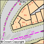
| Sample Data: | Click here for a larger sample image of OS MasterMap Topography layer | ||||||||||||||||
Not found what you are looking for? Please ask a question or give feedback by emailing (digimap@ed.ac.uk) or chatting with the Digimap team.
Share a to this page.
You may also find more information or communicate with us on our Social Media sites:
|
© University of Edinburgh. |