![]()


![]()
| Data Download Version | April 2018 |
 |
|||||||
| Download allowance: | No limit |
||||||||
| Formats Available: | |||||||||
| Version in Roam: | N/A |
||||||||
| View in Roam: | N/A |
||||||||
| Terms of Use: | |||||||||
| Copyright Statement: | © Crown copyright and database rights 2020 Ordnance Survey (100025252) |
||||||||
| Scale: | 1:1,250 |
||||||||
| Tile Size: | OS MasterMap® ITN Layer Urban Paths Theme is not supplied in tiles, it is a continuous dataset that covers the whole of Great Britain. When you select an area of this dataset you will be supplied with the features that lie wholly or partially within that area as follows:
|
||||||||
| Example Uses: |
|
||||||||
| Official Information Sources: |
|
||||||||
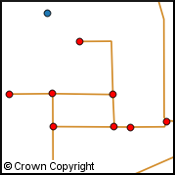
OverviewOS MasterMap® ITN Layer Urban Paths Theme is a logical network consisting of path centrelines in a link and node structure and includes man-made footpaths, subways, steps, footbridges and cycle paths in all urban areas of Britain over 5 km2. It has been created to encourage multi-modal travel in Britains towns and built up areas. The Urban Path Theme extends the functionality of the ITN Road Network Theme and Road Routing Information (RRI) Theme by using additional line links and nodes to join up path and road centrelines so users can develop their own bespoke networks combining different modes of transport. |
|||||||||
| For more information about the product see the official Ordnance Survey User Guide: |
|||||||||
Additional Information |
|||||||||
| Styling Files: |
|
||||||||
| Printable Legend: | N/A | ||||||||
| Sample Data: |
N/A |
||||||||
Not found what you are looking for? Please ask a question or give feedback by emailing (digimap@ed.ac.uk) or chatting with the Digimap team.
Share a to this page.
You may also find more information or communicate with us on our Social Media sites:
|
© University of Edinburgh. |