![]()


![]()
| Data Download Version | April 2016 |
 |
| Download allowance: | 200 tiles |
|
| Formats Available: | ||
| Version in Roam: | N/A |
|
| View in Roam: | N/A |
|
| Terms of Use: | ||
| Copyright Statement: | © Crown copyright and database rights 2020 Ordnance Survey (100025252) |
|
| Scale: | 1:10,000 |
|
| Tile Size: | 5 x 5km |
|
| Example Uses: |
|
|
| Official Information Sources: |
|
|
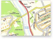
OverviewNote: This dataset is no longer updated. OS Street View® will be withdrawn by Ordnance Survey as of March 2017. OS Open Map - Local (Raster) is recommended as a suitable alternative. OS Street View® is a raster dataset, and as such when viewed in online maps the features cannot be turned on or off. Street View is street-level, backdrop map data that is specifically designed for online applications. It provides a scanned image of street-level mapping that can be combined with other data in a geographical information system (GIS), enabling you to clearly visualise a wide range of information in a geographical context. The street-level detail of OS Street View makes it particularly useful for displaying specific localities.
|
||
| For more information about the product see the official Ordnance Survey User Guide: |
||
Additional Information |
||
| Styling Files: | N/A | |
| Printable Legend: | ||
| Sample Data: | Click here for a larger sample image of OS Street View | |
Not found what you are looking for? Please ask a question or give feedback by emailing (digimap@ed.ac.uk) or chatting with the Digimap team.
Share a to this page.
You may also find more information or communicate with us on our Social Media sites:
|
© University of Edinburgh. |