![]()


![]()
| Data Download Version: | July 2019 |
 |
|||||||||||
| Download allowance: | 400 tiles |
||||||||||||
| Formats Available: | |||||||||||||
| Version in Roam: | July 2019 |
||||||||||||
| View in Roam: | Various (as Overlay) |
||||||||||||
| Terms of Use: | |||||||||||||
| Copyright Statement: | Contains Ordnance Survey data © Crown copyright and database right 2020 |
||||||||||||
| Scale: | 1:50,000 |
||||||||||||
| Tile Size: | 10 x 10km |
||||||||||||
| Example Uses: |
|
||||||||||||
| Official Information Sources: |
|
||||||||||||
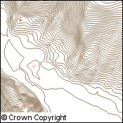
OverviewOS Terrain 50 provides an ideal base to enable the third dimension for other data within an appropriate geographical information system (GIS). It can be used for analytical, modelling, planning and visual purposes. OS Terrain 50 contours are not used in Digimap Roam. OS Terrain 50 contours is a contour dataset of 10 metre interval standard contour polylines which includes mean high and low water boundaries and spot heights. |
|||||||||||||
| For more information about the product see the official Ordnance Survey User Guide: |
|||||||||||||
Additional Information |
|||||||||||||
| Styling Files: |
** Additional style files exist for GML data loaded in to Oracle and PostGIS using GO Loader from Snowflake Software: these can be found here. |
||||||||||||
| Printable Legend: |
N/A |
||||||||||||
| Sample Data: | N/A | ||||||||||||
Not found what you are looking for? Please ask a question or give feedback by emailing (digimap@ed.ac.uk) or chatting with the Digimap team.
Share a to this page.
You may also find more information or communicate with us on our Social Media sites:
|
© University of Edinburgh. |