| Data Download Version: | April 2020 |
 |
|||||||||||
| Download allowance: | 400 tiles |
||||||||||||
| Formats Available: | |||||||||||||
| Version in Roam: | January 2020 |
||||||||||||
| View in Roam: | Various (as Overlay) |
||||||||||||
| Terms of Use: | |||||||||||||
| Copyright Statement: | © Crown copyright and database rights 2020 Ordnance Survey (100025252) |
||||||||||||
| Scale: | 1:10,000 |
||||||||||||
| Tile Size: | 5 x 5km |
||||||||||||
| Example Uses: |
|
||||||||||||
| Official Information Sources: |
|
||||||||||||
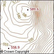
OverviewOS Terrain 5 provides an ideal base to enable the third dimension for other data within an appropriate geographical information system (GIS). It can be used for analytical, modelling, planning and visual purposes. OS Terrain 5 contours are not used in Digimap Roam. OS Terrain 5 contours is a contour dataset of 5 metre interval standard contour polylines which includes mean high and low water boundaries and spot heights. |
|||||||||||||
| For more information about the product see the
official Ordnance Survey User Guide: |
|||||||||||||
Additional Information |
|||||||||||||
| Styling Files: |
|
||||||||||||
| Printable Legend: | N/A |
||||||||||||
| Sample Data: | N/A | ||||||||||||