![]()


![]()
| Data Download Version | January 2020 |
 |
| Download allowance: | 200 tiles |
|
| Formats Available: | ||
| Version in Roam: | January 2020 |
|
| View in Roam: | Street View |
|
| Terms of Use: | ||
| Copyright Statement: | © Crown copyright and database rights 2020 Ordnance Survey (100025252) |
|
| Scale: | 1:10,000 |
|
| Tile Size: | 5 x 5km |
|
| Example Uses: |
|
|
| Official Information Sources: |
|
|
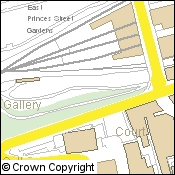
OverviewVectorMap Local (VML) Raster is a useful contextual map backdrop that has been generated from large-scale source information. The dataset is typically used to provide geographic context to a users own data. VML Raster is available in three colour palettes:
The resolution of the data enables the patterns of development within the landscape to be clearly seen, making the product useful for analysing data within urban areas. NOTE: There is also a Vector version available from Data Download. |
||
| For more information about the product see the official Ordnance Survey User Guide: |
||
Additional Information |
||
| Styling Files: | N/A | |
| Printable Legend: | See pages 22 - 24 of the OS VectorMap Local Raster User Guide |
|
| Sample Data: | N/A | |
Not found what you are looking for? Please ask a question or give feedback by emailing (digimap@ed.ac.uk) or chatting with the Digimap team.
Share a to this page.
You may also find more information or communicate with us on our Social Media sites:
|
© University of Edinburgh. |