British National Grid
Introduction
The position of any point in Great Britain can be described by its National Grid Reference. These references are often used in conjunction with Ordnance Survey maps, and are used to give the names of individual Ordnance Survey data tiles.
Grid Reference composition
Grid References consist of:
- two letters, optionally followed by
- an even number of digits, optionally followed by
- a quadrant name: “NW”, “NE”, “SW” or “SE”, standing for North West, North East, South West and South East.
These components are usually written without spaces. However, spaces are included here for legibility.
Example British National Grid References
- SK 07,
- SK 07 SW,
- SK 042366.
The First Two Letters
Two letters together identify a 100km square, and are derived as follows:
1
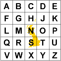
The first letter identifies a 500km square, from the diagram shown here. Ordnance Survey’s products lie completely within four of these 500km squares: H, N, S and T. The letters are allocated in alphabetical order from left to right and top to bottom, and omitting the letter “I”.

2
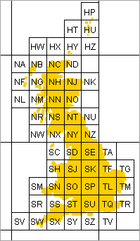
Each 500km square is then divided into twenty five 100km squares, and these squares are then labelled using the same pattern of letters. The resulting 100km squares covering Great Britain are shown here.

The digits
The digits identify a location within a 100km square.
- The first half of the digits give the Easting, or distance East from the edge of the 100km square.
- The second half of the digits give the Northing, or distance North from the edge of the 100km square.
If there are:
- 2 digits: the Easting and Northing are each in units of 10km;
- 4 digits: the Easting and Northing are each in units of 1km;
- 6 digits: the Easting and Northing are each in units of 100m;
- 8 digits: the Easting and Northing are each in units of 10m;
- 10 digits: the Easting and Northing are each in units of 1m.
- No digits? The Grid Reference applies to the complete 100km square.
The quadrant name
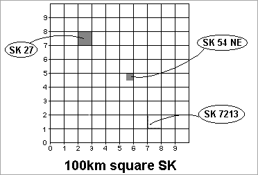
If there is a quadrant name present, it indicates one quarter of the area indicated by the rest of the grid reference.
For example, within the square SK:

Eastings and Northings
Eastings and Northings are measured in hundreds of thousands of metres (100,000 metres). The origin of the National Grid is 000000 (metres) East and 000000 (metres) North. For example, Jedburgh is at NT6520 or 365000 East, 620000 North. However, National Grid references are measured differently, using letters to represent the 100km reference, for example, NS123456. When using the Digimap Gazetteer service, you may need to convert from standard National Grid references to Eastings and Northings.
In a National Grid reference, the letters identify a 100km square and the digits identify a location within that 100km square. The first half of the digits give the Easting, or distance East from the edge of the 100km square. The second half of the digits give the Northing, or distance North from the edge of the 100km square. Notice that there is always an even number of digits - usually 2,4 or 6.
Convert Grid Reference to Eastings and Northings
To convert a National Grid Reference to Eastings and Northings:
-
Remove the two letters at the beginning of the reference: e.g. NS1234 becomes 1234
-
Split the reference into its East and North components: e.g. 12 East and 34 North
-
Work out the numerical reference for the two letters: e.g. NS = 200km East and 600km North.
-
Use the diagram below to calculate how many 100km units east and north the bottom left hand corner of your square is. For example, square NS is 200km East and 600km North of the origin, which becomes 2 units East and 6 units North.
-
Add the appropriate 100km reference to the beginning of the rest of the reference (remembering to omit the letters): e.g. 212 East and 634 North.
Since Eastings and Northings are measured in metres, you will need to add zeros to make the Eastings and Northings of the correct magnitude: e.g. 212,000 Easting and 634,000 Northing.
Example conversions
-
10km (2-figure) Grid Reference: SO84 = 380000 Easting 240000 Northing
-
1km (4-figure) Grid Reference: NS2468 = 224000 Easting 668000 Northing
-
100m (6-figure) Grid Reference: TL123456 = 512300 Easting 245600 Northing
Technical background
The details of the construction of the National Grid from latitude and longitude is mathematically complex.
In summary, the process is that the irregular shape of the Earth is approximated by an ellipsoid or spheroid. This spheroid is then transformed onto a flat surface using a mathematical transformation known as a projection. The National Grid is then a cartesian coordinate system calculated on the resulting flat surface.
Different spheroids and projections are used in different countries and regions of the world. For Great Britain, the technical details are as follows:
Spheroid
Name: Airy Spheroid (1830) Semi-major axis: 6,377,563.396m Semi-minor axis: 6,356,256.910m
Projection
Type: Transverse Mercator (also known as Gauss Kruger) True Origin: 49° North, 2° West False Origin: 400km West and 100km North of True Origin Scale factor on central meridian: 0.9996012717